
Beside the water on an old map of Tokyo stands a building shaped like a squared-off C. The three characters beside it say umamisho, a place to watch horses. A broad white band runs between the building and the water. Trace it with a finger and it takes you all the way round the pond, back to the stand. This is Shinobazu Pond in Ueno Park. Enlargement of the pond on the 1894 Shitaya police district map

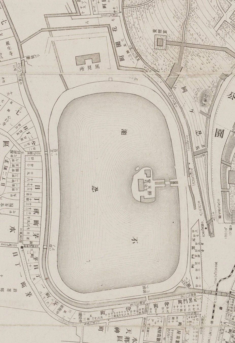
Tokyo Shitaya Police District Map, May 1894. Look for the stand on the upper bank. Cropped and rotated 90 degrees clockwise to put north approximately at the top. Edited by 長田連豊. Taito City Central Library. Catalogue and original · CC BY 4.0
First, forget a bridge
Count the bodies of water on a present-day aerial photograph. The Cormorant Pond is in the zoo’s West Garden to the north, the Boat Pond to the west, and the Lotus Pond to the south. Bentendō, the temple hall on the island, stands between them. A visitor who walks around the Boat Pond today completes a much smaller circuit than a horse once did. The horses ran around the outside of all three bodies of water together. Put the stand on the northern bank, trace the southern curve along what is now the Lotus Pond, and follow the western side along Ikenohata. Tokyo Metropolitan Government park map · Edo-Tokyo Museum on Shinobazu Pond
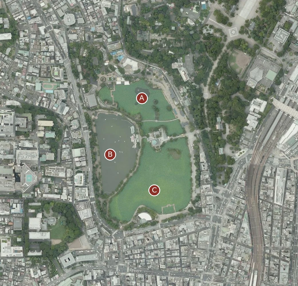
A, Cormorant Pond. B, Boat Pond. C, Lotus Pond. Geospatial Information Authority of Japan seamless aerial photography, joined and lettered for this article. North is up. The letters identify present-day water. Open in GSI Maps · Tile information
The easiest place to catch yourself taking a wrong turn is west of Bentendō. Enlarge the 1894 map. Just one approach reaches the island, from the east. No path continues to the west bank. Kangetsukyō, the bridge that made that crossing possible, was built for the 1907 Tokyo Industrial Exhibition. An embankment followed, dividing the water. Walking west from the hall makes perfect sense today. In the horses’ time you would have been walking on water. Edo-Tokyo Museum’s sequence of maps, p. 3
A racecourse could vanish and still leave a shore behind
Turn back seven years before the opening, to a survey of the park dated 1877. Find the temple island and follow the shore towards the northwest. The water tapers into a projection where the Aizome River once entered the pond. In 1884 the Joint Racing Company filled that projection and reshaped the shore for the course. The first meeting took place on 1 November. It is tempting to look for a track hidden under modern buildings or trees. Part of the evidence is in plain sight in the shape of the water itself. Taito City Central Library on the 1877 survey · The library’s account of the earthworks
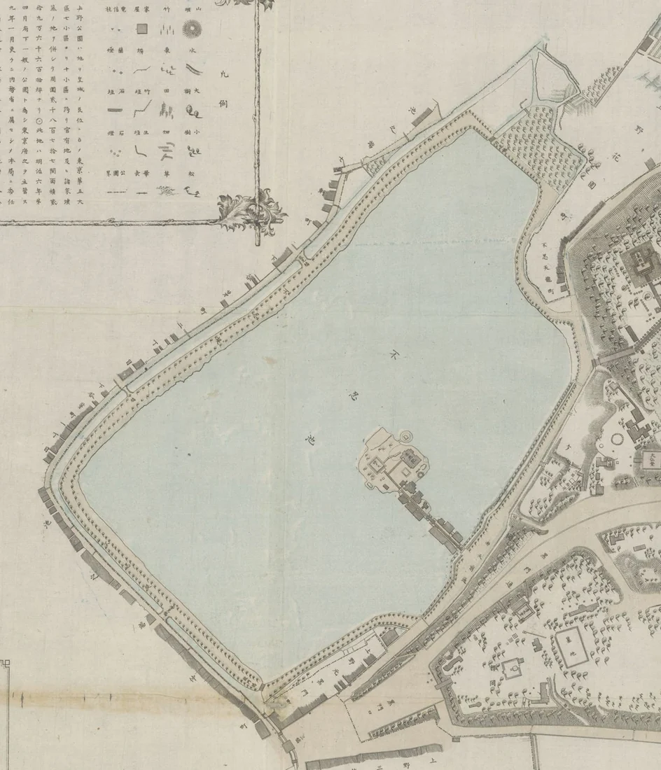
Detail of the 1877 survey of Ueno Park, cropped in the original orientation. North lies roughly towards the upper right. Use the island and its eastern approach to compare it with the aerial view. Produced by the Museum Bureau and surveyed and drawn by the Geography Bureau’s survey section. Taito City Central Library. Original · CC BY 4.0
Why did the artist give so much space to people watching?
Read Yōshū Chikanobu’s 1885 triptych from left to right. Horses bunch together on the left. Boats and a Japanese flag occupy the middle. The stand all but takes over the right-hand sheet. If the point was to show the horses, why give the audience so much room? A meeting at Shinobazu was a social occasion for the imperial family and diplomats. Guests of honour occupied the northern stand. Ordinary spectators could watch from places along the outer fence. Where you stood changed what you saw of the same lap. National Diet Library’s triptych · Foundation for Cultural Heritage and Art Research on the stand and fence
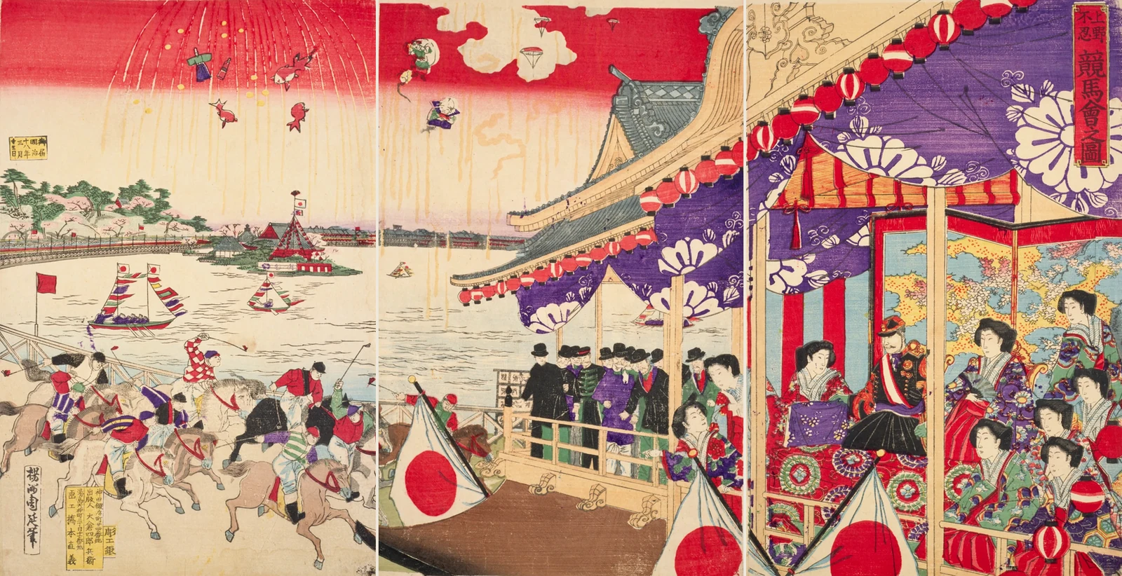
Yōshū Chikanobu, racing at Shinobazu in Ueno, 1885. National Diet Library. Margins trimmed and scans 3, 2 and 1 joined from left to right. View the individual sheets
Taito City Central Library points out that many prints of these races were prepared in advance as publicity. They show the spectacle visitors were invited to expect. They are a poor place to measure the precise location of the winning post. For the physical relationship between fence, stand and runners, a contemporary photograph is a better witness. Taito City Central Library exhibition notes · Period photograph of the stand and track
How close can you get to the hoofprints?
Regular meetings ran from 1884 to 1892. The police district map dates to two years after they ended. It preserves the name of the stand and the relative positions of building, track and water. The Edo-Tokyo Museum puts a lap at about 1.5 to 1.6 kilometres. A contemporary description gives the track a width of twelve ken, about 22 metres. Picture a band that wide and it becomes clear why you cannot identify one strip of modern paving as the exact line the horses followed. There is even a photograph of another race meeting in 1906. The end of the regular fixtures does not give us the date of the last hoofbeat. Museum account · Course width and construction records · Photograph and newspaper coverage of the 1906 meeting
Look north from Bentendō on your next visit. Across the water you will be facing people who once looked down from the stands. The maps cannot put your feet beside an individual fence post. They can tell you something equally satisfying. Standing on that island, you are inside the horses’ circuit.